


The Continental Drift pt. I
A Journey to the Center of the Earth - 1996

On to: The Drift part II / The Drift part III
How to (re-) trace the continental drift
[ Originally written as “Crazy Geology / Crazy Geography” in September 1997 and edited more than once; now, edited again ]
"Scientists have known for long that the Sun's photosphere rotates faster at the equator than at the poles."
Here is a theory I have been working on as a hobby since around 1982: That this is a common trait of all rotating stellar objects which are able to do so, be they liquid or gaseous, big or small, from galaxies over stars and planetary systems down to the planets themselves.
This would be because when rotating objects contract due to their own gravity, their core, becoming more compact, begins to rotate faster than their surface, a difference that is necessarily most marked at the equator and least at the poles, maybe even forming a vortex there. It's a pirouette effect.
So, not only is the equatorial region traveling faster than the polar region, the center is also revolving faster than the surface - as long as the stellar object is fluid and not rigid, like, say the Earth's moon - which then may usually solidify with a displaced center of gravity, finally stopping rotation almost altogether, while locking it to the next strongest center of gravity in the vicinity.
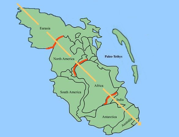
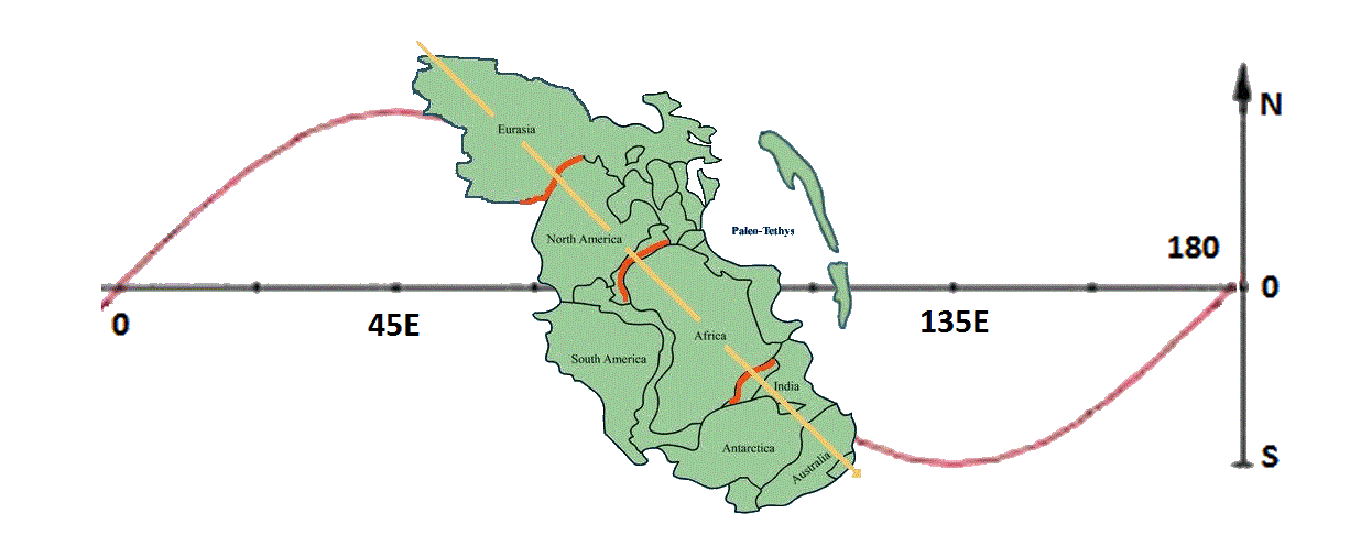
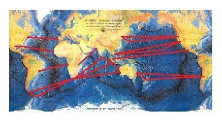
I came across this idea by looking at a map of our own planet and trying to trace the continental drift by retracing the spreading zones on the Earth's surface as shown on the globe.
One of the strange facts lies in that there are no mountain ranges on either side of the Atlantic or Africa, or to the south of India, where in plate tectonics theory they should be, opposing the mid - ocean ridges.
Obviously, during the last few hundred million years, no tectonic subduction has taken place to the south of India, nor to the west of Africa and Europe, nor east of the Americas; tectonic subduction has concentrated on the north of India, and, to the east of the Pacific, on the west coast of the American continents; and north of the Mediterranean Sea.
By retracing the sea floor spreading and running it forward again, the startling effect is therefore a clear eastward flow of the continents along the equator, with a circular hole at the north pole ( more continental mass being in the northern hemisphere ) and a circular land mass at the south pole.
[ This, by the way, is a result of, or leads to the result, that there are no antipodes to speak of on this planet; wherever there is continental mass on one side of the globe, you can be pretty sure there is an ocean on the opposite side; and not only that, it even seems that this has been so for very much of the time throughout the world's history, though heaven knows why. Unless, of course, it is a function of the sinus flow yet to be discussed below ]
Precise measurements by satellites also seem to show that the Earth is bulged out slightly at the North Pole, while being slightly indented at the South Pole. This, if correct, gives the Earth a somewhat pear-shaped appearance. This could be a sign of material being transported from one pole to the other, probably from South to North Pole via the core.
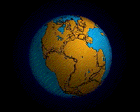
Exploding Pangaea
The standard animation, which explodes Pangaea in all directions away from Africa ( which therewhile remains more or less static ), is probably due to our Euro - and therefore, Africa - centered view onto the globe.
It accounts for sea floor spreading in the Atlantic and Indian oceans, but not in the Pacific.
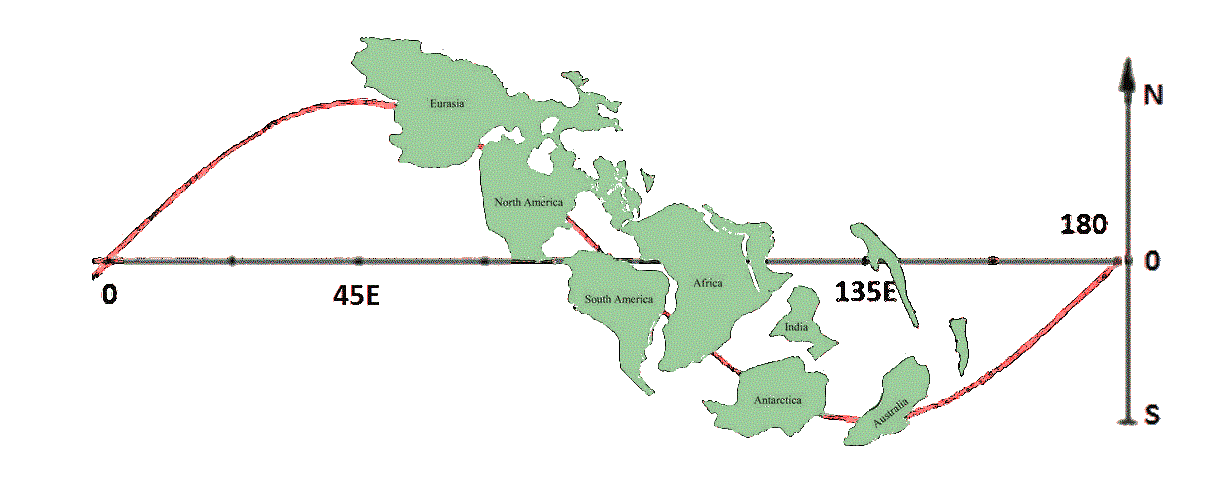
My idea now is that the continents are, instead, being carried along by an eastward equatorial stream within the Earth's mantle, which is driven by the Earth's core rotating faster than the surface.
There is a sinus overlay to this magma flow, which runs - complete with swirls and eddies -
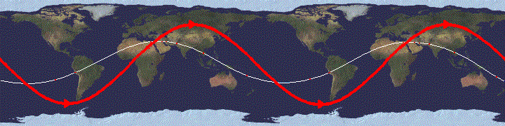
• down and up past Cape Horn ( the very distinct blow - out effect of this can be seen on the ocean floor in the Falkland region - and maybe the Caribbean ),
• then northeast under Africa and India - and, in fact, Australia - ( all three being passively carried along with this flow of magma as on a conveyor belt - therefore no subductive mountain ranges along their coasts! )
• into and under Europe and Asia, forming the Alps and Himalayas and all the ranges north and east until it wells up again, forming the Darwin Rise, Japan,
• and bursting out toward the southeast, opening the Pacific to form the North and South America's western mountain ranges.
The "scars" of this process are distinctly visible on the ocean floors - and on the continental crust as well.
Weirdly, this assumed magma flow seems to follow the projection of an "ecliptic" ( i. e. the position of the noonday Sun ) onto the planet in exaggeration; which may, if so, be a result of the Sun's gravitational pull, combined with centrifugal forces, causing it to meander in the described fashion.
[ This gravitational pull of the Sun, together with that of the Moon and the rest of the solar system, may even contribute to the effect of slowing down - or rather, holding back - the outer shell of the Earth. That may even be a contributing cause of Earth retaining an interior of molten magma at all.
Perhaps even the fact that the Earth passes nearest the Sun when the northern hemisphere ( and the arctic ) is facing it, due to the inclination of the Earth's axis, is contributing to the fact that there is more land mass concentrated in the north than in the southern hemisphere ]
• Why so many continental fractals are triangular with a tip to the south, I have no idea, but there must be a mathematical reason for this. Could this have some connection with the three branches of the alpide mountain chain / trench systems with their vortexes north of Australia and the under the Indian Ocean, respectively?
• And maybe even with the seemingly likewise threefold ridge - and - valley system on the outer core, the "Vogel-Bumps", as proposed by Prof. Dr. Vogel of the Free University, Berlin?
Or is it just purely mathematical?
And is it just my preconceived impression, or do series of tremors sometimes seem to run around the world from west to east?
Anyway, the triangular nature of these two main geological vortex systems seems to be the cause of the impression that, when retraced, the continents are shown to be drifting eastwards in forward motion, as it fixes a spot on an otherwise indeterminable global surface.
What are the consequences?
I don't know.
It's just an ideé fixe.
You can perhaps compare it with this animation (source unknown). There are quite a few similarities:
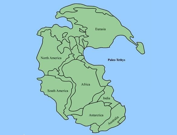
Model: The breakup of Pangaea
In light of the supposed sinusoidal mantle flow below the Earth's crust above:
Pangaea, Model 1 (future Eurasia lies east of future North America):
Pangaea, Model 2 (future Eurasia lies west of future North America):
The breakup of Pangaea over the undercurrent southeasterly mantle flow:
Note: Although Model 2 was used in this depiction, Model 1 is far more consistent with both objective fact and the undercurrent equatorial magma sinus flow hypothesis as proposed here.
In fact, it is still not nearly consistent enough; even in Model 1, future Eurasia needs to be placed much further to the south. The Atlantic ocean is a real rift, opening not only between South America and Africa, but between Canada and Scandinavia as well.
Furthermore, Africa needs Eurasia as a counterpart to push future Europe Tethys seafloor into, folding up the alps, as India forms the Himalayas.
Not taken into account at all is the amount of continental deformation and real crust subduction; the continents, then, did not have the shape of the continents now - where now there are mountains, millions of square miles of former continental crust lie hidden below ( and above ) ground level:
Proto - India, for instance, would have to have had a now - Tibet bulge, not a dent, to its former northeast, now its north; i. e., the former Indian continental land mass that now lies buried under the plateau of Tibet behind the Himalayas, squashing out the territory of China to the east of Asia.
Similar phenomena can be seen in the Colorado plateau in the US, or in Europe, under almost half of which lies what was once the northern range of the Proto - African continent - again, behind the alps (behind in all cases meaning seen from the point of thrust, i. e. here: the south).
The ( superficial! ) geological boundary between North and South now lie within the Alpine resp. the Himalayan mountain ranges; the subterranean boundary lies far beyond.
All things taken into account, a more fact - consistent Pangaea Model would look a bit different, a bit more compact and elongated differently, and the sinus flow magma undercurrent would be more compact as well to stay in proportion; and, this being a map, not a globe, the northern and southern regions would have to be disproportionately spread as in the sinus flow depiction above.
This schematic depiction serves only to illustrate the principle.
The results up to now:
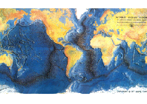
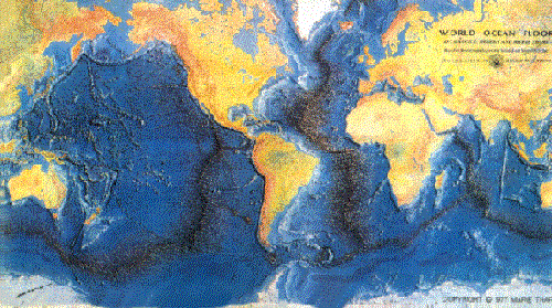
The following was fabricated by cutting up and re - pasting and lastly painting over that by now famous world map of the continents and ocean floor from the 1960's by Bruce Heezen and Marie Tharpe:

As I never got round to work it out on a computer, it remains a crude paper model done on a Xerox machine all those many years ago, of which I have made a scan available on Youtube. [ And a less redacted alternative ]
How to arrive at the results:
• Note the black mid - ocean ridges; these are the planetary tectonic spreading zones, while the bright - orange continental mountain ranges are the subduction zones that are being compressed.
• Note also the triangular connection of the spreading zones in the Indian Ocean and the location of the new, alpide mountain ranges towards the west and north, as these are important; note the triangular connection of the Alpide, Andean and the half- submerged Indonesian mountain chain (the Pacific “fire ring”) in the Himalayas.
• The mid - ocean ridges are always the most newly - formed crust on this planet, corresponding with the age of the thereby compressed alpide mountain ranges.
Now:
• To rewind the continental drift backwards through time, the mid - ocean ridge area is reduced step by step, and the alpide mountain ranges spread out or de - compressed accordingly.
• The result is that the continents have now moved west. The triangular connections of the spreading zones enforce this, together with the location of the alpide mountain ranges.
• Alas, the size of the continents is greatly exaggerated in this rather rough animation, but the result is an elongated form of Pangaea reaching over the poles.
• We shall now run the continental drift forward again by re - spreading of the ocean floor and re - compressing the Alpine / Andean mountain ranges.
• The result is that the continents have to move east during the continental drift.
• This may be because the core of the Earth is rotating faster than its surface, dragging the continents and ocean floor along with it towards the east.
The rather simple trick is to reduce bit by bit the sea floor spreading in relation to the mid - ocean ridges:
Wherever there is a rift or basin, close this by x on each side, along the line of thrust, perpendicular to the rift or mountain chain.
Open corresponding trenches and spread corresponding mountain ranges accordingly.
Repeat this procedure step by step until all recent rifts and basins are closed, and all recent mountain chains have been flattened and spread out.
Of course, this only works if the Alpine - Andean mountains ( which by today have lost most of their volume due to erosion ) are allowed to spread out in consequence, and the continents themselves are thus allowed to deform - or rather reform - in the process; for instance, the mountain ranges of the Alps, once a series of marine sediment basins, in part now lie hundreds of kilometers "inland" from their original location.
Who says the continents have always had the same shape as today? Dr. D. Neev and Dr. J. K. Hall, of the Mapping and Tectonics Division, Israel, many, many years ago did some research on this aspect but, as far as I know, met with very little response.
So, plausible assumptions have to be made about the original expansion of the so treated continental compression zones; whether they once represented sinks, possibly submarine, and the like.
However, the outcome of this drift - retracing ( an oblong - shaped Pangaea, which extends over both Poles ), is less arbitrary than it may appear at first glance; it roughly corresponds with its present - day scientific image, but shows the way to get there - and thus a way to extrapolate into the future.
Or expressed in another way: Sister Cities
Karachi and Daressalam, had they existed at the time, would have been neighboring cities, now torn apart by the continental drift; as were
Kapstadt, Colombo, Djakarta and Perth; further east,
Sydney, Wellington and Santiago; up north,
Mexico and Singapore;
the former Saigon, Manila, Honolulu and Los Angeles;
above, Peking, Tokyo, Seoul and San Francisco;
and finally, Miami, Monterey and Dakar, Boston and Lisbon, Rio de Janeiro and Luanda.
Furthermore,
The Cape of Good Hope and Cape Horn were one, but no cape; and the Drake Street was closed by Antarctica.
Behold:
All island chains to the east of the continents were once eastern coastal regions of these continents, torn away by the easterly magma flow as postulated above.
There are NO island chains ( or basins, for that matter ) to the west of continental shelves!
This observation cannot be sufficiently stressed.
Just as there are no real subduction zones, or therefrom resulting mountain chains, in or beyond the eastern regions of these continents.Instead, mountain chains in the eastern regions of continents, as in North and South America, Asia, or Australia, are not subductive, but former rift rims; they always ( ! ) have their counterpart further east, across the ocean, symmetrically divided by a mid - ocean ridge or basin.
This process can be seen developing today in the East African Rift Valley.
And some of these counterparts have, indeed, turned into the above mentioned island chains.
The Indonesian island chain down to the island of Bali, for example, which seems to be in the west of the Australian continent, apart from being volcanic, in my model is, in reality, continental debris that once belonged the eastern coast of Africa, resp. the western coast of North America ( some of it is even found in the Rocky Mountains ); while the islands south - east of Bali belonged to the eastern coast of Australia resp. the western coast of South America - both of which are still being carried eastwards.
The separation runs somewhat along the "Wallace Line", which indicates a long separation between these two parts of a conglomerate, which off - hand look like they have always belonged together; but the strait between them is up to 1500 meters deep and is termed an oceanic "graben".
Thus, just as continental shelves may be torn apart to wander separately across the planet, so they may be joined at the far ends of the world to again form something new.
Or to put it even more bluntly:
• The surface of this planet has but two true subduction zones; southern Eurasia and western America.
• And I am not even sure if they cannot be counted as one, maybe excepting the Indonesian branch to New Zealand.
All continental bits and pieces have thus traveled far, but none as far as Africa itself, which has since then traveled around the world at last once - although this is difficult to state, considering it is a round trip on a globe; but more than once Africa will be, or has been, like the Moon sailing around the world, in the place from which it started from.
This easterly flow then is not weak, but very strong.
My conclusion is that the continents ( all of them ) are moving generally EAST ( some just faster than others ), ever since the beginning, driven by the Earth's core rotating faster than its surface by about 1 extra revolution every 900 years, that being a fact which seems to have been proven by now ( see below ).
I had estimated ( rather guesstimated, not measured ) 1 extra revolution in every 1,000 years, which is pretty close; this would be making its influence felt as an equatorial surface drag of roughly 200 meters per extra core revolution, displacing trillions of tons of rock by 200 meters every millennium.
Some put it even higher than that.
Furthermore, there seems to an idea that really disruptive earthquakes sequence events or 'storms' take place in somewhat regular intervals of around 400 years, with lulls in between.
If this were so, it could perhaps be connected to the somewhat 3 - fold irregularities of the Earth's core, as will be described, which would then pass under any given location closer to the equator about once every 300 - 350 years … but this is just speculating.
The Earth - Moon gravitational spiral
I also believe that the Moon, for similar reasons, has a displaced center of gravity facing Earth, for being part of a spiraling gravitational system that has its center in the Earth's core ( and this indeed seems to be the case, as in "tidal locking" )
One marvels on how thin the Earth's crust really is, compared with it's massive interior; and how mountain chains, though the may seem high to us, and indeed have their peaks almost up in the stratosphere, they are but shallow crumples that can easily be formed by the huge forces that hold this planet in it's path.
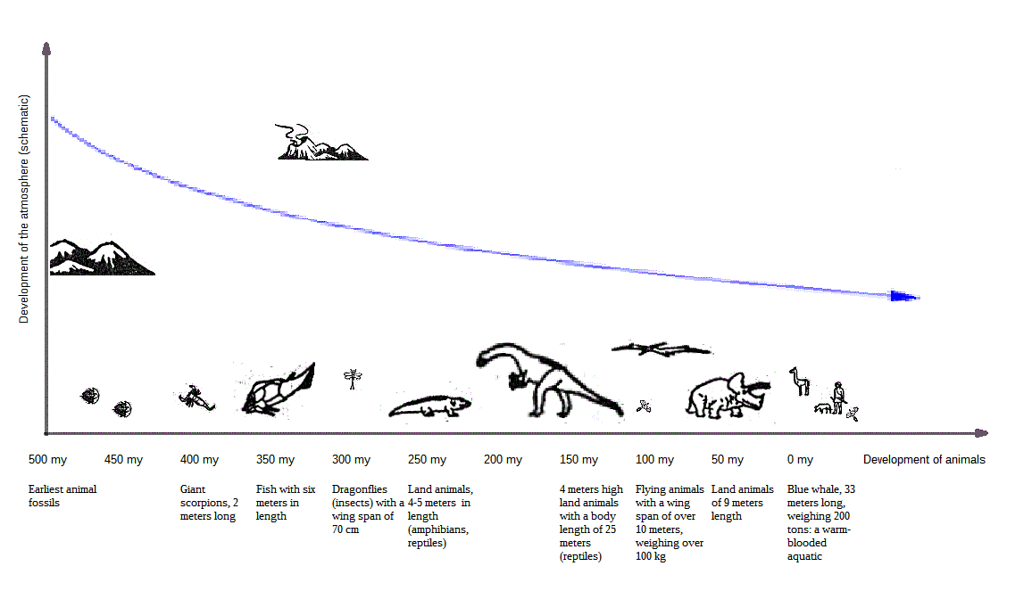
Speaking of said stratosphere, the Earth's atmosphere may in prehistoric times have had 2 - 3 times the volume, pressure and density of today, enabling bigger and heavier creatures to breathe and fly ( dinosaurs, pterodactyls and, even before that, gigantic insects and other arthropods ), as well as forming a different climate. Maybe even allowing for higher mountains by elevating the erosion levels.
If so, questions remain:
• Why and how has the Earth's atmosphere disappeared?
• And is this still going on? At what rate? And has the development of birds and Mammals have something to do with that?
[ Fear not for now, Archaeopteryx will also turn up - later. ]
Addendum 2006:
Now, as it seems, while I was wrestling with plate tectonics and found that the solution to the observed problems could really only be found in a postulated superrotation of the Earth's core, Paul Richards and Xiaodong Song from Lamont - Doherty had concluded from analyzing seismic waves of earthquakes that the Earth's core must indeed be rotating faster than the surface.
And this seems to have been confirmed by new research which apparently hit the news in the August 26 issue of the journal Science, 2005.
They calculated that the Earth’s core is rotating approximately 0.3 - 0.5 degrees faster than the rest of the globe. In addition, there apparently is an inhomogeneity or "lumpiness" of the inner core. ( Again, see the "Vogel Bumps" )
The inner core has a diameter about three - quarters that of the Moon, and a mass about 30 per cent greater than the mass of the Moon.
This inner core rotates in the same direction as the Earth, but seemingly completes its once - a - day rotation a little bit quicker than the planet as a whole. The studies also indicate that the fast - track axis is not exactly north - south but is tilted slightly at about 10 degrees from the Earth's own axis and moves eastward. Over the years, it would trace a circular path around the north pole.
If the so - called "superrotation" of the inner core is of the order of 0.3 degrees to 0.5 degrees each year, this means that in about 900 years the inner core would gain one full rotation on the rest of the planet, which would be about 50,000 times that of plate tectonic motion.
( Others seem to calculate around 1 degree per year, which would result in one extra core revolution in just 360 planetary surface years. )
Remember, I did not know of this at the time …
Does this mean that the core of the Earth is moving 50,000 times faster than the surface?
No:
• In 900 years, which are 900 x 365 or roughly 300,000 days or planetary rotations, the core completes 1 extra rotation, giving it 1,000003 times the speed of the planetary surface on the equator line.
• Or 20,000 extra rotations during the 20 - odd million years it took that part of Africa once to become India and Tibet to be dragged across the Indian Ocean and rammed into central Asia.
Now that it seems established that there IS a superrotation of the Earth's core, maybe someone will be able to measure its influence on the Earth's surface. As far as I know, this has not yet been recognized as a possible motor for the continental drift.
One down, one to go.
Then perhaps we can throw some previous assumptions out of the schoolbooks
Addendum 2011:
The sad catastrophe of the earthquake and tsunami that hit the main island of Japan on March 11, 2011 (known as the Tohoku, Sendai or Miyagi earthquake) seems to have moved parts of the east coast of that country -in fact, the northern half of that main island- eastwards by some 3 - 4 meters, expanding the country, and parts of the ocean floor to the east of it by as much as 20 meters or more as shown here (taken from science.org). [I.e., not westwards]
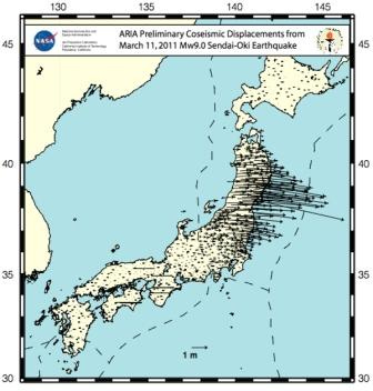
Yes, that can be explained by a rebound effect. And yes, there is a subduction zone.
Perhaps, though, Asia, and with it Japan, along even with the Pacific Plate, is being carried, pushed and torn ( south - ) eastwards, the effect being more marked the further east you go, thus opening the Sea of Japan basin, not closing it: This enhancement of the slippage along the direction of the movement from (north-) west to (south-) east points to crustal expansion, not compression.
The similar would then apply to Australia and New Zealand.
Such would be the rather dramatic consequence of this idea.
* * * * * * * * * * * * * * * * * * * * * *
[ "Descend into the crater of Yocul of Sneffels, which the shade of Scartaris caresses, before the kalends of July, audacious traveler, and you will reach the centre of the earth. I have done it." ( Arne Sagnussem )
- Jules Verne, JOURNEY TO THE CENTER OF THE EARTH ]
ARNE SAKNUSSEMM