


The Continental Drift pt. III
Drifting Time and Distance Estimates

Back to: The Drift part I / The Drift part II
How far have the continents traveled? And in what time?
And can we re-run it?
I ) The first clue: Archaeopteryx ( latitude )
The fossil remains of Archaeopteryx, a link between reptiles and birds, and about the size and weight of a modern-day raven, have been dug up in Solnhofen, Germany.
So, one could assume that some 150 million years ago, it was this that once was the natural habitat of Archaeopteryx:
• A cool climate north of the Alps, with fresh water and trees all around, which would be
• Seemingly the perfect environment for a bird to evolve out of a tree - climbing reptile
However, from the fossil record, one can see that the surroundings, in which this evolution is supposed to have happened, were not at all like they are today; birds, at least Archaeopteryx, apparently did not evolve in a cool, wooded northern mountain side environment.

Instead, one can safely say that
It was rather a tropical lagoon in a very hot desert climate with any allusion to trees, for example petrified driftwood, completely missing.
This lagoon was partitioned into basins by marine sponge reefs.
It was over - salted, oxygen - deficient and therefore hostile to life.
Occasional storm tides washed a wealth of marine animals and plants over the reef barriers in the south again and again … they quickly perished in the poisonous lagoon water, sank to the ground and were just as quickly covered up, secured and conserved by following layers of lime mud.
So, to all effects, about 150 million years ago, what was to become part of the South of the German mainland lay to the north of an open ocean, the Tethys, surrounded by a belt of coral reefs.
Rocky, rugged, and treeless beach landscapes by the sea in which Archaeopteryx combed these beaches for crawfishes, worms, and fish, and nesting on cliff sites, from where they started their, maybe, compared with modern birds, a little clumsy, flights by jumping off the cliff - that seems to have been that environment.
Archaeopteryx, possibly like all dinosaurs in flight, and like modern-day bats, being creatures with no or not yet fully developed feathers, have a difficult time starting off level ground, especially if there is no wind at ground level to throw themselves into. Bats therefore tend to hang on to cliffs, caves ceilings and trees, and so probably did the flying dinosaurs - and so probably did Archaeopteryx. Many of these creatures have, or had, sharp claws with which to climb and hang from.
This way, flight may have developed by jumping off heights with the help of wind and gravity, not against it ( the question remains however, how, only 50 million years before, dinosaurs of maybe 200 kilogram living weight were able to fly, a feat that is biologically completely impossible today ).
On the other hand, allowing even for an overall hotter climate, tropical coral reefs do not thrive in the regions of the northern Atlantic, or even the Mediterranean; and there also remains the mystery of the missing wood.
The answer results from the drift distance of the continental plates moving, which, in this region, according to some sources, amounts to an average of about 37 km northward in one million years; if not necessarily at a constant rate.
So it seems that, 140 million years ago, the Solnhofen plate limes lay about 5,200 km further south than today, i. e. on the latitude of Cameroon, and, drifting north, some 70 million years ago passed through the latitude of the Tibesti Mountains in the middle of the Sahara Desert.
About that time, the Indian plate began its very rapid northward drift at an average speed of 16 cm / year, covering a distance of about 6,000 km, up to the collision of the northwestern part of the Indian passive margin with Eurasia in early Eocene time ( 48 - 52 million years ago ).
Since that time and until today, the Indian continent continues its northwards movement at a slower but still surprisingly fast rate of about 5 cm / year - as so does Africa, at about the same speed.
Therefore, going by the fossile record, the described marine or shoreline habitat of the living Archaeopteryx used to lie somewhere in the region between south of Cameroon and the Tibesti Mountains in the Sahara Desert.
Right in the middle of this distance today there lies the slowly desiccating and oversalting Lake Chad, and some surviving Nile crocodiles still inhabit the few remaining creeks in the shadows of the rocks of those Tibesti Mountains in the middle of a huge and impassable desert.
But it had not always been impassable.
According to latest findings, 40 million years ago - just about when ( Proto - ) India collided with ( Proto - ) Asia - the North African Saharan Desert was, at least partially, the shallow, mangrove - lined floor of the Tethys Ocean, which was then elevated during the migration of the African Continent to the north - and that on the northern edge, so that whale bones were found in, probably cut off, desiccated former Saharan sea basins, and shell fossils of corresponding age are found in the limestone of the Egyptian pyramids.
In all these considerations, it must be emphasized that the present-day Mediterranean is a recent, centrally 3,000 meters deep sea basin, probably torn open by shear forces, as would be the following chain of basins, becoming ever flatter towards the east, of the Black and the Caspian, even the Aral Sea, since the ( still continuously growing! ) Alp Mountains, which were raised out of the former ocean over the time span of about 100 to 20 million years ago, lie to the north of it, while Africa still pushes from the south; and yet this Mediterranean sea - other than the one that previously lay to the north of India - seemingly is not being closed by these forces, but torn open.
Impulsed by the African continent, and / or carried along by the postulated magma flow, Eurasia could now be separating itself once again from Africa, to the northeast, along the line from England to India.
Anyway, it remains a fact that the floor of the former connecting sea, the Tethys north of the original Africa ( which extends, on the surface, to the Pyrenees and to the Alps, and reaches even further north below that surface ), indeed has already been closed some time ago, and now makes up the chalk and marble Alpine Mountain ranges.
And indeed, the rocks that make up the Alps are considered to be of African origin.
The African / European boundary, therefore, lies to the north of the central Alpine Mountain ranges, not to the south of it - just like the Indian ( former African ) / Asian boundary lies north of the Himalayas:
The Mediterranean Sea, along with its Italian ridge, is, geologically seen, part of the African continent, not of Europe.
500 million years ago, this Proto - Africa lay in the South Pacific on the East of Pangaea. And about 200 million years ago, the North African coast, which was to form part of the Alps, had its greatest extension.
Beyond it lay a shallow ocean, at least 500 kilometers wide, and one to the west ( the directions "north" and "west" as seen of today; Africa then probably lay turned slightly clockwise south of the equator as part of Pangaea, it's today's north pointing rather northeast; the present - day Atlantic had not yet opened to the west of it ).
All in all, it is said that the Alps, presently 100 kilometers wide, consist of compressed ocean floor and formerly European and North African coastal regions, which, together, once were more than 1000 kilometers wide ( and therefore one can consider using a 10 : 1 ratio when discussing how far alpide mountain ranges can be expanded to fill the gaps of disappearing ocean floor while trying to retrace the continental drift ).
This continental compression tilted gigantic, formerly horizontal rock slabs, impressive thousands of meters thick, at any angle up to vertical, so that, by chance, footprints of comparatively small dinosaurs - which are said to be 200 million years old - now run up a rock wall near Lake Garda in the Italian Alps, which were, once, a coral lagoon reef.

On the other hand, the origin of the, now lower, Variscan Central European mountain ranges north of the Alps - and therefore north of the now closed former Tethys - from the North American Appalachian Mountains to the Urals in the east, which constitute the geological boundary to Asia, and beyond - stem from an earlier era, some 300 - 360 million years ago; and how far, and how long, later Western Europe - as well as the Midwest of the United States and much of Siberia - was below sea level after the breakup of Pangaea, is moot.
Deep sea oceans of 1,000 to 10,000 meters depth are former rifts, and often have recent spreading basalt sea floors. However, shallow oceans of a few hundred meters depth, such a the Adriatic, Baltic and North Sea, are not; they are inundated continental shelves.
So, the present-day Mediterranean Sea was, probably, originally not part of the original Tethys, but part of a later North African rift, the edges of which tend to lift themselves upwards. This corresponds with its history of periodic desiccation in the time range of 6 - 5 million years ago by the closing of the Straits of Gibraltar ( and, of course, the Sinai ) - similar to the present-day East African Rift Valley, which, like its Red Sea extension, the Jordan Rift Valley, lies partly below sea level at 400 meters.
Which, by the way, forces all of Mediterranean, Southern Europe, i. e. Portugal, Spain, Italy, the former Yugoslavia, Hungary and Greece, to be of African origin as well.
Around this same time, 5 - 4 million years ago, another important strait was closed, the one between the North and South Americas, changing the climate on both sides of the Atlantic.
The Panamanian Land Bridge emerged alongside with humans in Africa, and placental mammals from the North displaced marsupials, even large ones, in South America ( while in Australia, it seems to have been the other way round; supposedly, because marsupials can stand harder conditions, with shorter, interruptible gestation ).
In Africa, however, marsupials seem to have been at a disadvantage from the outset. Madagascar, separated from Africa along with the first Atlantic around 170 Million years ago, has no marsupials, but lemurs, a primate group that landed there around 70 million years ago.
As sediment cores furthermore show, today's Sahara, probably no later than 3 million years ago, turned from a then rainy freshwater swamp of the central African type into a desert with the severe climate variations since the beginning of the so - called Quaternary glacial period about 2.5 million years ago; this is not only due to falling dry by the raising of the region itself, but due also to it wandering through the Earth’s northern Trade Wind Desert Belt.
This itself shifts - probably within the precession period of the Earth's axis of about 26,000 years - from north to south and back again; just 7,000 years ago, in the midst of a now glowing desert, early farmers had settled beside a lake.
The subsequent transition to a desert, then, took place, as shown by other sediment cores, about 5,000 years ago, within a mere 100 - 200 years, and the people of the area probably crowded into the Nile Valley in Egypt, to build a highly cultured civilization; just at the time when, north of the Mediterranean, in the Alps, a man with the later name of "Ötzi the Iceman" was shot to death and remained buried under snow and ice for the next 5,000 years.
Since then cold and snow rule the Alps, while a mere 2,000 km further south rule drought and heat, separated only by a warm, but very deep, inland sea.
Were the Alps warmer, when the Sahara was cooler? 10,000 years earlier, the ice age ended on the northern hemisphere; 15,000 years from now, and the Sahara could be moist and green again.
Apart from all that:
If, at the time of 140 - 70 million years ago, the former Alpine region lay in place of today's Africa, then where lay Africa?
This question might not be that uninteresting, as not far from Solnhofen, in Messel, the remains of early primates of 50 million years and of pre - humans some 5 - 10 million years ago have been found - which, as we know, originated in Africa.
50 million years ago, by the way, is also about the time some small predecessor of the camel went into the sea and turned into the whale, whose earliest fossils have been found somewhere in the Himalayan mountain range ( and later ones, as mentioned, in the North African Saharan Desert ).
But, where did all that happen?
It does indeed seem possible that at that time the Alpine Region, and with that the natural habitat of Archaeopteryx, lay not on the southern shores of Europe, but rather opposite, on the on the southern shore of a northern ocean, namely the Tethys, which was being pushed up by the African plate; and therefore not only geographically on the northern shore of the then African continent, but actually so, as the original outline of this continent still show up today, along the lines of the Pyrenees - Alps - Carpathians - Caucasus - Iran - Afghanistan, telling us just how far the former African continent has been pushed ( or pulled! ) under the Eurasian plate, tilting that to the north and letting the ocean run off, as was India under Tibet; this all the way up to the Tienschan mountains; and therefore, both, probably much further than is generally assumed.
A magma flow, which can cause such a thing in such a short time, has therefore to be quite formidable; and such a view would also not prerequisite, if not outright prohibit, rigid continental plates unchanging in size.
Perhaps even, at that time, the later to become Germany still lay under the waters of the Tethys, which also splashed over the North American plains, and what today forms the Middle East and Arabia - and all of which 140 to 150 million years ago lay much closer to the equator.
Now, the question remains, of whether, and how far, the whole structure has also moved along the Equator - and, if so, in which direction.
II ) The second clue: Amber ( longitude )
Amber is found in layers of blue aluminum oxide, in the northern Baltic Sea as well as in the caribbean Dominican Republic; there, still in those mountains, which were reduced to sand, mud and ocean rubble by the glaciers of the ice age in the northern Baltic Sea region.

Amber is about 45 million years old, unpetrified fossil resin.
So, some 45 million years ago, two subtropical blue - clay regions with amber resin trees of various kinds ( which, by the way, also are said to bear resemblance to some of South-East Asia! ) lay, if so, then, perhaps not very far from each other, in two locations which are now separated in longitude by a young ocean, and additionally by 30 degrees of latitude; the eastern location having subsequently, in approximately the last 50 million years, been separated from the western one by about 10,000 kilometers to the east and 4,000 kilometers to the north.
The Solnhofen region of Archaeopteryx’s origin would then have moved about half that distance extra, the African plate burying itself under Europe, building up the Alps, thus shortening the distance to the Baltic - and therewith lifting central Europe out of the sea, tilting it slightly and so letting most of the water run off to the north.
Assuming that in this model the caribbean Dominican Republic stayed, more or less, on the same latitude, this gives us a rough estimate of the strength and speed of the equatorial magma flow below the crust, in this region of the planet, indeed, flowing to the north, but in the same time flowing twice as fast to the east.
III ) Conclusion
The 10,000 kilometers drift to the east in 50 million years, multiplied by three in 150 million years, puts the fossil site of Archaeopteryx, that now constitutes the northern banks of the Alp Mountains in southern Germany, about three - quarters around the world onto what are, now, the coral reefs of Borneo and Northern Australia; and, following the assumed sinus mantle flow, this fits in nicely with the assumed latitude of that landscape:
We find ourselves, again, at the height of Cameroon; albeit on the other side of the planet this time:
Some 5,200 km further south than today, and 30,000 km to the west.
Addendum 2010:
This also puts the original location of the fossil site of the German Archaeopteryx quite near to the Liaoning fossil site on the eastern coast of China ( which lies to the west of the pacific and atlantic expansion, and therefore has not moved, relatively seen ), where mysterious and controversial feathered dinosaur fossils of corresponding age have been dug up - and, oh yes, amber.
150 million years ago, both MAY have constituted a common habitat - perhaps even a common coast line.
10,000 kilometers drift in 50 million years would also constitute an average of 20 centimeters per year of absolute drift to the east, on a surface dragged along by, as others have found, a planetary core completing one extra revolution ( roughly ) every 1,000 years, thus making its influence felt as an equatorial surface drag of ( equally roughly ) 200 meters per extra core revolution every 1,000 years.
In the light of a displacement of trillions of tons of rock by 200 meters every millennium, earthquakes are no wonder.
Would that be too much, and what would it have to be measured against?
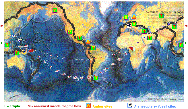
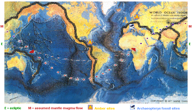
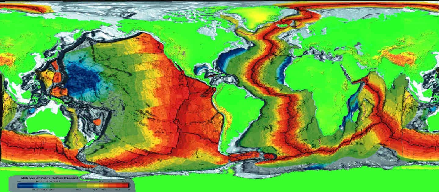
E = Path of the sun's ecliptic ( position of the noonday sun )
M = Supposed west - east magma flow under the Earth's crust
Black Borders = Maximum extent of the primary subduction zones - i. e. the original ( if distorted ) outline of recently subducted continental or oceanic plates.
A = Amber sites
Archaeopteryx symbol = Archaeopteryx fossil site
( white: recent; yellow: presumed Archaeopteryx living site, roughly; note the similarity in the black subduction / mountain chain )
Red T on green: Tethys Ocean ( ? ) mineral oil deposits ( presumed oil fields, in part, roughly; created from oceanic plankton of the extremely warm Jurassic to Cretaceous period - about 200 to 100 million years ago ) - added just out of curiosity; outdated ( would also show the easterly flow ).
It might be interesting to follow the path of the early hominids ( primates and pre - humans ) drifting along on and with the African continent, predominantly in the eastern and central, and as it seems, northern parts, albeit of much younger or later origin than Archaeopteryx. Thus making the old world monkeys to new world monkeys.
Data basis for flash or morphing experiments
Tracing the Continental Drift may not be that easy, as the data is only available here to about 50 % .
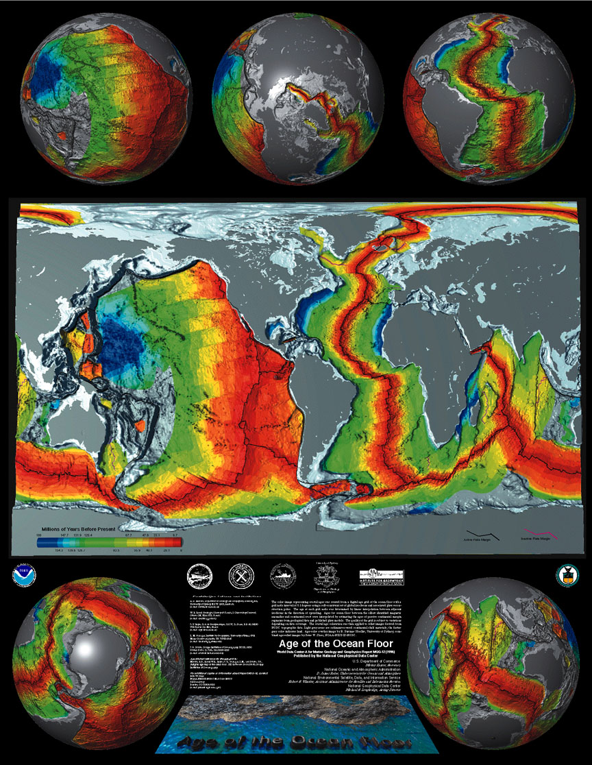
However, a great site full of pictures, globes, maps and links on geomorphology is http://www.ngdc.noaa.gov/mgg/mggd.html which can be searched for images, such as this one depicting the age of the Earth's crust.
Using this, you need to have the specific ages of the corresponding mountain ranges, then try to reduce the ocean floor in reverse according to its age, as depicted by the colors ( which would then not yield exactly the same results as my ancient first try, but near enough to prove my point, I would say ).
This oceanic reduction will not work, unless one has continental crust to expand accordingly.
To illustrate the last 200 - 250 million years at issue here, one can superimpose the map of the alpine mountain ranges on top of the abovementioned picture, and resize it to fit.
But, while the age per kilometer of spread-out ocean floor and continental crust is relatively well known, the age of the same, buried under mountains, is only as a whole.
And to what extent continents and ocean floors were deformed by subduction and mountain building, can only be estimated; here, the data basis leaves us.
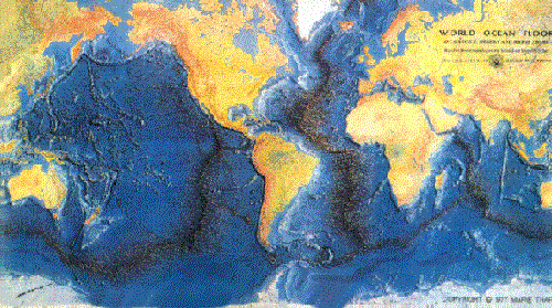
For a start, I have taken another map and superimposed it upon the above and added a bit of guesswork here and there


( assuming that the seafloor spreading was more or less uniform over time; this need not have been the case ).
It cannot be said with certainty how old the consecutive folded mountain ranges are down below, in accordance with the ocean floor. But I would say a successive unfolding, as a straightening of crumpled table cloth, so to speak, would be in order.
A ratio of about 10 : 1 has already been established above:
Until the Alps, the Himalayas, the Rockies and the Andes are completely straightened out and flat, they would reach over an area ten times of the recent - and not forgetting to add the subducted area to the subducted continent itself, if there is one.
How far would this be?
This is a matter of common sense, speculation and whatever the machine will make of it. And, perhaps, of an erosion relation of 10 : 1 as well.
And finally, the continents will have to be torn apart, for where they are now, there was once ocean floor; in fact they consist of it for the most part.
( Note: The black structure in the green part of the Pacific running from Kamchatka in Asia in the northwest to the Hawaiian Isles in the southeast could be taken as a mid - ocean ridge for that part of the ocean floor at the time of its expanditure ).
Good luck.
By now, it should be no problem using some form of AI assistance, I would guess.
For comparison, here they are in a zip-pack.
And here’s the first try once more as an ancient animated xerox gif
As I never got round to work it out on a computer, it remains a crude paper model done on a Xerox machine all those many years ago, of which I have made
a scan available on Youtube (here’s a less redacted alternative)
and here are the slides that make up the video or gif.